Academics
Units of the Institute
The roles and responsibilities of each unit of the institute are summarized below.
- Seismology and Earthquake Geotechnical Engineering Unit:
This Seismology and Earthquake Geotechnical Engineering Unit is responsible for running permanent seismic stations de facto National Seismic Network of the country (ESSN). In the recent past, Ethiopia had M6+ earthquakes in 1906, 1961, 1969, 1983, 1985, 1987, 1989, 1993 and 1999. The Unit also provides advisory services to governmental, non-governmental organizations and several investors involved in the construction industry so as to erect earthquake resistant structures.
In Ethiopia earthquake monitoring started in 1959 and currently station AAE (Addis Ababa, Ethiopia) is known to be one of the world’s best in data quality and continuity of its operations. AAE, as part of the World-Wide Standard Seismic Network (WWSSN), was upgraded to a digital station in 1994 and 1997. It moved to a new location at Mount FURI where the current FURI station is located. FURI is affiliated to IRIS/USGS (Incorporated Research Institute for Seismology / United States Geological Survey). Besides, IGSSA has deployed other seismic stations in Dessie (DESE), Ankober (ANK), Harar (HARA), Semera (SEME), Kofele (KOFE), Dilla (DILA) and Arba-Minch (ARBA).
Among these stations, real-time data are obtained only from FURI and AAE. Meanwhile to monitor earthquake occurrences, real-time data acquired from these two stations (AAE and FURI) are not enough. Therefore, the Institute uses additional real-time data from stations in Djibouti (ATD) and Kenya (KMBO). For the same purpose, these countries also use data from IGSSA’s stations. However, the booming construction industry in the country demands the need for having more real-time stations in order to deal with risks posed by earthquake and their mitigation. To this effect, the connections of Dessie (DESE), Arba-Minch (ARBA) and Harar (HARA) stations have been established.

Seismic stations’ network (purple triangles) and location of earthquake occurrences (reds circles) in Ethiopia
Parallel to its routine monitoring and research works, this unit handles the duties of the National Data Centre (NDC), as Ethiopia has signed and ratified the Comprehensive Nuclear-Test-Ban Treaty CTBTO. Furthermore, this Unit serves as a member of the National Building Code Revision Committee, which is supervised by the Ministry of Housing, Urban Development and Construction.
- Geodesy, Geomatic and Gravimetric Unit
Geodetic work was started soon after the establishment of the Geophysical observatory. The collaboration studies with the Smithsonian Astrophysical Observatory, which were carried out from 1969 to 1976 in Adama, Chamo, Langano and Dobi areas, are among the early prominent accomplishments. Between 2001 and 2004 deformation in the Main Ethiopian Rift were studied under the EAGLE project and from 2007 to 2012 active geodetic activities were also carried out in the Afar Region through the Afar Consortium Project.
In collaboration with the Technical University of Darmstadt and the Federal Agency for Cartography and Geodesy (BKG) of Germany, in 2007 IGSSA established the first permanent GPS station that provides real-time data. It constitutes an International Global Navigation Satellite System (GNSS) Stations delivering data necessary for various applied and research purposes. At present this Unit runs 24 continuously operating GPS stations in Ethiopia in collaboration with local universities (Haramaya, Adama, Arba-Minch, Mekele as well as metrological centers in Bahirdar and Robe) and international partners, such as the Universities of Purdue (PU) and Massachusetts Institute of Technology (USA).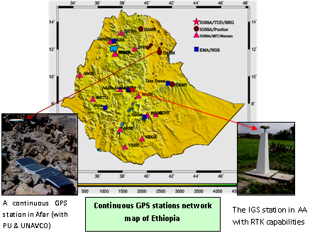
Utilizing satellite and other space-borne data, the Unit conducts research related to the study of water mass balance of major river basins in East and North Africa regions, like that of the Nile. In collaboration with the Bristol University (UK) deformation patterns in the country are studied using Interferometric Synthetic Aperture Radar (InSAR) method. In partnership with AA Institute of Technology, Ardhi University (Tanzania) and the University of Edinburgh (UK), IGSSA has recently launched a new MSc program in Geodesy for East Africa.
The Unit is also currently engaged in curriculum development for land management with special duty in the geodetic and geomatic programs, which is a collaborative work with the Ministry of Housing, Urban Development and Construction.
- Applied Geophysics Unit
This Unit runs the Addis Ababa Geomagnetic Observatory (AAGMO), which was established in 1958. This station is one of the very few geomagnetic observatories located under the geomagnetic dip-equator. AAGMO is an official member of the INTERMAGNET, a global network of geomagnetic observatories delivering high quality real-time data accessible to the international community.
The Applied Geophysics Unit also delivers advisory / consultancy services to various governmental and non-governmental (including private) organizations through provisions of different geo-scientific data related to groundwater, mineral explorations and geotechnical investigations, including landslide and related geo-hazard investigations whose outputs are required for the planning and implementation of civil engineering projects.

Geophysical studies for groundwater investigation in the drought-affected areas of Borena Zone (Oromyia Region, Ethiopia) have been successful. When the low gravity and low electrical resistivity anomalous zone was tested by drilling, a groundwater potential of 22 lt/s was discovered.
- Astronomy and Space Science Unit
The Astronomy and Space Science Unit is relatively a new unit under IGSSA and studies about space environment. Space weather refers to conditions on the sun and in the solar wind, magnetosphere, ionosphere and thermosphere that can influence the performance and reliability of space-borne and ground-based technological systems that can affect human health. Our ever-growing dependence on space-based technologies, such as satellite communication, navigation systems as well as sensitivity of electricity generation to space weather will result in an increasing need for understanding the space environment. IGSSA and the Physics Department of AAU have engaged in studying and monitoring space environment through magnetometers, GPS and Space Radar installed at Wolemera Woreda of Oromiya Regional State, Ethiopia.
In the past few decades, the harmful impacts of human beings on the planet have caused increased concern, such as ozone hole, global warming, flooding and drought caused by climate change and acidic rains caused by urban pollution. To understand and alleviate these problems, the study of climate science, using different techniques, such as satellites, ground sensors and computer models is becoming indispensable.
- Atmospheric & Oceanic Sciences Unit
The Climate Science and Remote Sensing research carried out in AAU ranges from climate change impact assessment, flood and drought prediction, ionosphere variability, outdoor to indoor climate monitoring, computational fluid dynamics and chemical analyses of the earth’s atmosphere. Apart from research, this Unit also provides consultancy services in major climate issues.

Using the FTIR spectrometer, monitoring and analyzing the content of atmospheric greenhouse gases is studied. Some of the atmospheric gases observed by FTIR are O3, H2O, CH4, NO2, N3O, CFCs, HNO3, CO, NO, etc.